
Driving Directions: Return to Rose Avenue (CR 22) and exit town the way you entered, then take the left fork crossing the river on CR 22. In 1.2 miles turn left on Curtis Mill Road (CR 299), which reenters the Apalachicola National Forest. Continue 6.4 miles to the intersection with Sopchoppy Highway (US 319). Turn right (south) for .3 miles to the entrance of this beautiful state park.
Distance and driving time between this and previous stop: 7.9 miles / 10 minutes.
Minimum time: 30 minutes
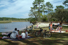
Description: This jewel of a park is located where the Ochlockonee and Dead Rivers intersect. Ochlockonee, which means "Yellow Waters," is a mix of brackish, tidal surge, and fresh water. Wild and deep, the river empties into the Gulf of Mexico. Trails allow visitors to explore the park and view the diverse wildlife including nesting Red-Cockaded Woodpeckers, White Squirrels, Manatees, Alligators, Otters, Bobcat, Coyote, Black Bear, and White-Tailed Deer, as well as natural communities such as pine flatwoods and oak thickets. Both freshwater and saltwater fish inhabit the waters around the park. The site also includes a marked swimming area, interpretive panels, picnic tables, and boat ramp with canoe rentals.
Other Nearby Destinations: Wood Lake Recreation Area.